
As I looked out the window, the plane turned and the magnificent Cotopaxi crater came into full view below me. I hadn´t seen the mountain the whole trip and now as I left it was right before my eyes. It almost put me in tears from seeing it for the first time. It was pure magic, gaspingly beautiful and yet untouchable and fascinating. This was nine years ago and I knew I had to come back and meet this stunning active volcano with my own two feet. Here I am, years later, training to summit this beast of a mountain at 19,347 feet or 5,897 meters in elevation, called Cotopaxi in the Andes Mountains!

Quito, the capital and closest big city, is at 2836 meters or 9,350 feet so I guess just landing here and staying a bit you are halfway to the top. Cotopaxi can be climbed year round since it is so close to the equator but they say December to February is the best timeframe (may also be busiest). My plan was to train for three weeks in hopes to have gained fitness at high altitude and then attempt the summit at the end of January. I waited a few days after landing in Quito to start any higher hikes. Technically after 2-3 days your body should be fully adapted to the new altitude. The body automatically increases red blood cell production to compensate for less oxygen to the blood stream. Truthfully you could prepare for the Cotopaxi summit in about 10 to 12 days but still your body may not adjust so I preferred to stay longer and allow more time to acclimate. My training plan was to summit at least four high peaks in the area. Make one be above 5000 meters (would be a first for me to go up this high) and potentially spend the night above 4500 meters. I also wanted to be sure to train distance or really time out on the trail because just to reach the summit of Cotopaxi it takes between 5 and 7 hours of major effort. Mind you in those hours you only cover 2.4 miles!
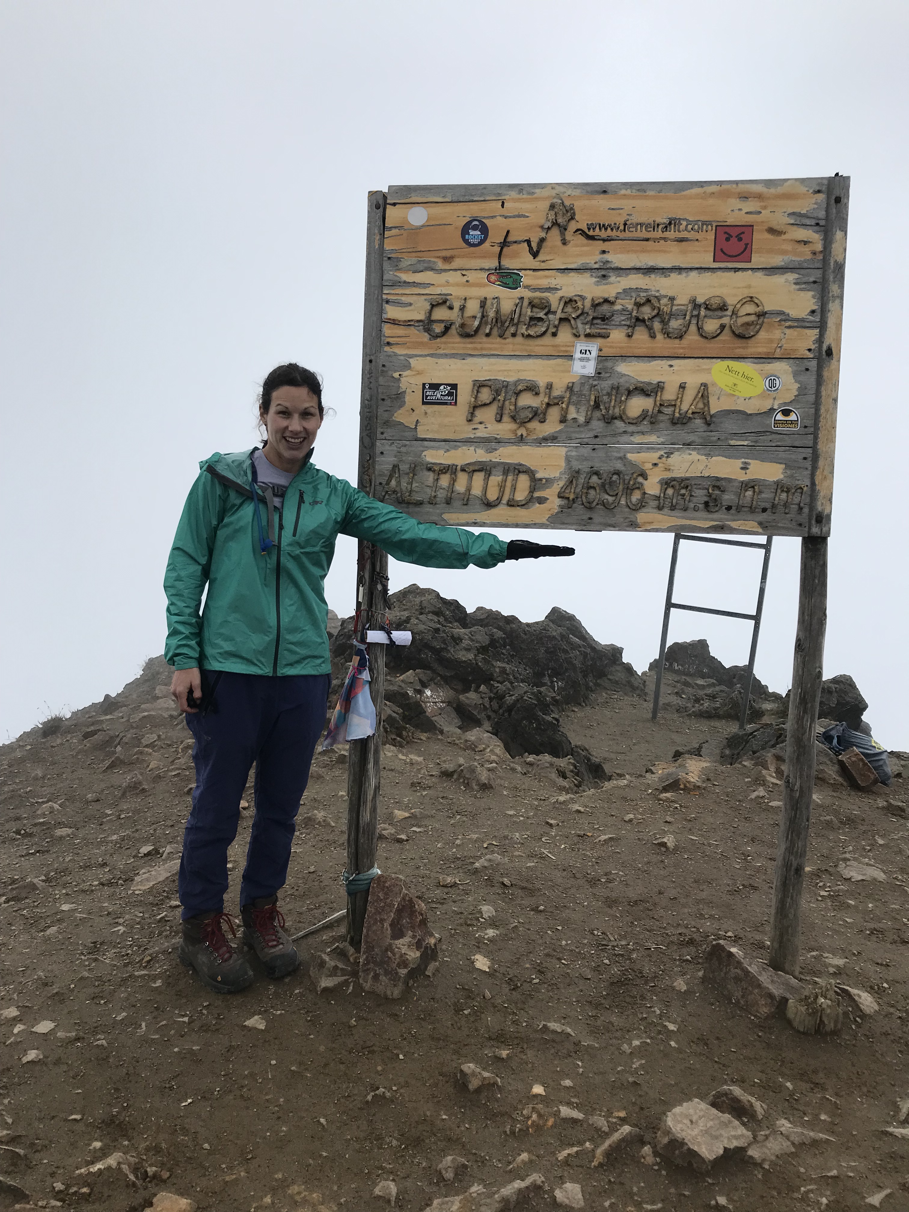
It seems everyone does Ruco Pichincha as their first summit, which is easily accessed here in Quito and is at 4696 meters. It is a great hike because you can take the TeleferiQo (the ¨Q¨ is for Quito, otherwise it is spelled with a ¨c¨) in town to 3800 meters or so and then walk to the summit. Of course, I too did this as my first hike. I remember taking the TeleferiQo years ago and really feeling the altitude just walking up there so I was not sure how I would feel this time or even if I would make it to the peak but sure enough I did, and surprisingly I did so without too many issues in the altitude. Obviously, it was not easy specifically the last part to the summit as it is quite steep and very sandy therefore I had to stop and catch my breath plenty but it was totally do able and there is no need for a guide here, it is a very well marked trail (red and white markings plus blue signs – ignore yellow signs as that is for a more technical route) and very popular on weekends (avoid weekends, if possible).
This was the plan for training:
1- Ruco Pichincha (4696m)
2 – Quilotoa Loop
3 – Pasochoa or other above 4000m
4 – Pichincha Integral (multi summits, Guagua being highest)
5 – Imbabura or other at 4800m
6 – Illiniza Norte or other above 5000m
7 – Refugio Jose Rivas then summit Cotopaxi
More information on Hiking around Quito
I included the Quilotoa loop not for altitude but for the 3 days of walking, each day was about 4 hours of walking give or take walking through farmland, up and down valleys and finally the Laguna de Quilotoa at the end was a beautiful reward. It was also just something I wanted to do last time I was in Ecuador. Pasochoa was meant to be an easier day of hiking added to the mix. Then the last three peaks I made sure were done with minimal amount of days in between. By the time I got to the 5th on the list I felt ready to make the summit attempt and was not feeling a need to stay at a refugio above 4500 meters for a night. Illiniza Norte was a curve ball though, since I actually got a headache making summit, which worried me about the altitude for Cotopaxi.


To summit Cotopaxi most choose to go in a group, maximum 2 climbers per guide (that is according to local laws), to the top of Cotopaxi but I chose private because I was traveling alone and I didn´t want an unknown person joining who might not have prepared well forcing me to go down the mountain if they got sick so I paid more to go alone to increase my chances of making summit.
There are a few factors that could stop your attempt for summit, the least controllable is weather so you just need to put it in your head that you never know this factor, that you should always try for summit but that you might need to head back down due to weather (include avalanches here). The others are controllable factors and you can work at reducing issues with these factors. Besides weather the factors are, altitude, technical experience and physical fitness. For Cotopaxi the number one factor that seems to stop people is the high altitude and it´s super important to get hikes in at altitude to prepare. If you prepare for the altitude you should be fine but know there is still a slight chance that your red blood cells are not completely adapted to the thin air and it may present you with minor symptoms of altitude sickness or potentially worse (everyone responds differently and each mountain is different). WARNING: Cotopaxi´s summit is very high altitude and this should not be taken lightly, many parties trying to summit turn around for this reason alone. The next factor that you can control is technical experience which you can learn from other mountaineers or take a basic mountaineering class but either way know that Cotopaxi was not very technical and most anyone can climb Cotopaxi. The last factor is physical fitness which you can control by training. You should definitely invest time training most of the following ways: functional exercises, aerobic exercise, elevation gain simulation or actual, time on feet (distance walked, etc), stairs, actual mountain hikes and weight in bag walking/hiking/stairs.
The story goes that Cotopaxi being the young volcano it is began flirting with Mama Tumbaragua, the girlfriend of Chimborazo, the highest mountain in Ecuador, and the rivalry from the young Cotopaxi frustrated Mama and she erupt killing many people and causing lots of destruction. This ended the attempts by Cotopaxi and Chimborazo decidedly married her. Mama is the most active volcano in Ecuador and with Chimborazo they had a baby, Guagua Pichincha which sits literally above Quito. According to legend, when the baby cries or any jealousy occurs all three or at least one of these mountains tremble or erupt. These are just some of the stories I was told, but in Ecuador each mountain has a story about it told in Quechua, the local indigenous people´s language and culture. By the way, most volcanos in Ecuador are male, I believe only three are female (all named Mama ha ha) and of course the drama of females going crazy has to be there…
With training completed it was time to head to Cotopaxi National Park, provide the signed climbing permit and pay the $10 park fee (all arranged days before in order to enter to climb by guide/agency) and finally attempt to reach the summit of the magnificent and magical Cotopaxi which on a clear day stands perfectly dominant on the horizon was you head South out of Quito.


Summit attempt started at 11:30 pm. We had arrived to the Cotopaxi Refugio Jose Rivas by 5 pm that same day. We walked an hour from the parking lot to the refugio, dropped our stuff, ate, reviewed summit plan with my guide then we were off to bed for a few hours. I of course couldn´t sleep, I´ve been having issues getting to bed for a while and doing so before midnight I knew was going to be an issue. Throw in the fact that at 4800m breathing was not necessarily easy and I had to take some deep breaths every now and then to get the air needed. I rested though which was good. They say simply laying horizontally is restful for the body so if anything close you eyes and do just that. Also avoid sleeping pills as they mess with your breathing and won´t help you adjust to the thin air like the body needs. Just before midnight we got ready, ate a snack and set off within the hour.
From the refugio to the glacier is a 2 hour walk then from there to 5500m is another 2 hours and finally the last part to the top is 1.5 hours according to my guide. He also mentioned that you must make summit by 8 am otherwise it is too late as snow starts melting and becomes dangerous. As you summit at night with headlamp you really only see the feet in front of you. Waking up you have no clue what the weather will be. The forecast called for fresh snow and 30 mile an hour winds. When we walked outside it was clear, the stars were shining brightly and no clouds were around. They say you can never trust the weather forecast here and thankfully it was true because snow and strong wind did not sound helpful for making any summit. I was so happy to see stars but knew it could all change rapidly on the mountain. At least I was put at ease with this start.

Maybe I was tired or something but walking up this mountain I had zero excitement for the day. Maybe I just knew it would be a hard climb and my brain couldn´t get past that. Maybe it was I was alone and had no one to lift the mood for me this early or share the experience with except for my guide. Maybe I just didn´t really want to do a summit. Who knows but it was something I was trying to grasp as we trudged along up the mountain and something I was seeking to find because I felt it was missing.
I paid no attention to the altitude like I usually would while hiking. Instead I focused on moving steadily with my guide at a very slow pace as to not aggravate potential issues in the thin air. The best is to keep your head down and stay with the pace. I did try to pay attention to time passing but not in the sense of looking at a watch but rather I kept time visually in my head referring back to the map we looked at after dinner to get an idea of how far we had traveled (for instance, 2 hours to glacier…etc).

Once at the glacier, crampons were necessary. I had never once used them before! I thought maybe I did climbing Volcán Villarrica in Chile but after looking at photos we did not!. With crampons came roping in to each other (en cordada) should one of us find a crevasse (una grieta) or fall, we could save the other instead of plummeting to the bottom of a hole or head straight down the mountain at full uncontrolled speed. Safety was important and we also donned climbing helmets in case either event should take place.
I’m not going to lie, even with all my training and being fit, climbing Cotopaxi is hardcore. It is a very steep route the whole time. Using crampons on such a steep route means you destroy your calf muscles. To use crampons you never face straight but instead you are always crossing over each foot sideways almost and are facing out toward the slope. Also, each step you kind of dig into the snow so it is not a normal walk. If you don’t do it correctly after awhile it becomes quite brutal.
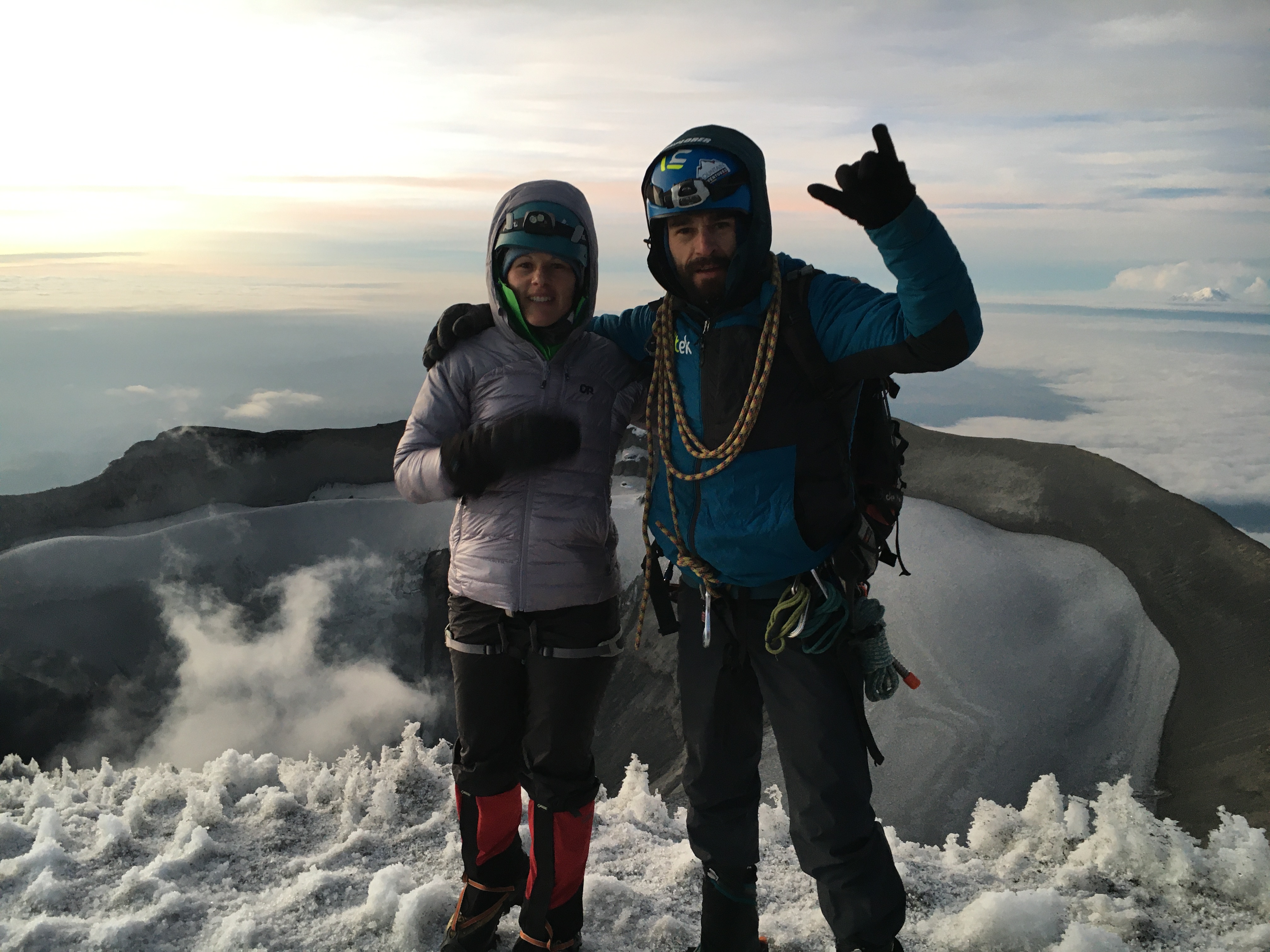
The higher we climbed the worse the calf muscles felt. Each step was harder to make especially when it was steep with steps to climb (left from other climbers). By this time my hips were really hurting and I got frustrated with the climb. I got mad at my guide because he wanted me to keep moving but it hurt and all I wanted was to know how to stop the pain. He never gave me much instruction when we started but instead just told me to follow as he did. Finally near the top he explained better how to walk to alleviate the pain some but it hurt and I was frustrated. Worried for my hip I began to cry. Climbing Cotopaxi did not seem made for me. I just wanted to get there and head back down. I was over the summit idea and just concerned about my hip. I pushed through the tears and the pain while trying to find the correct technique to ease the pain. It sort of worked but the calves were still on fire so each step was quite the struggle. Added to this was the fact that the thin air was making it hard to move fast and also began making my communication a mumble which was so bad my guide couldn´t understand me in Spanish or English. We only had a few minutes left until the first part of the summit (aka the rim) so we trudged onward but at an even slower pace now. Sunrise was maybe 30 minutes away and we started to find the other groups up near the top waiting in the cold for it. I was thankful that once we reached the rim of the crater the route flattened out a bit and gave some relief just before we reached the maximum summit.

All my training worked perfectly as I never had any symptoms of soroche/altitude sickness, which was wonderful considering the highest I’d climbed was two days prior up to 5100m and a horrible headache ensued for nearly 24 hours. This and the sleep/rest of only a few hours at the 4800m hut (…with mild breathing issues) of Cotopaxi before summiting. Knowing how to use the crampons better would be the only thing I felt lacking in my preparation.
The route down was a blissful reward after the slow trudge in the dark. Now everything we missed while going up could be seen with the sun shining brightly. All the beautiful snow now taking form and the route was clear as ever. Not to mention it is way quicker on decent. All this almost made you forget about what you just went through until you stopped and looked back up toward where you came from and remembered what was achieved. It took a total of 7 hours from refugio to refugio, of which 5 hours and 20 minutes was the effort to reach summit. The refugio includes breakfast (and dinner) in the price to stay and everyone was more than excited to get back for it…even if it was just tamale and fruit. lol

Visible route finally 
Just below the rim. Chimborazo in the distance! 
Almost back to refugio. Loved all the contrasting colors looking down off Coto 
Illinizas in the background 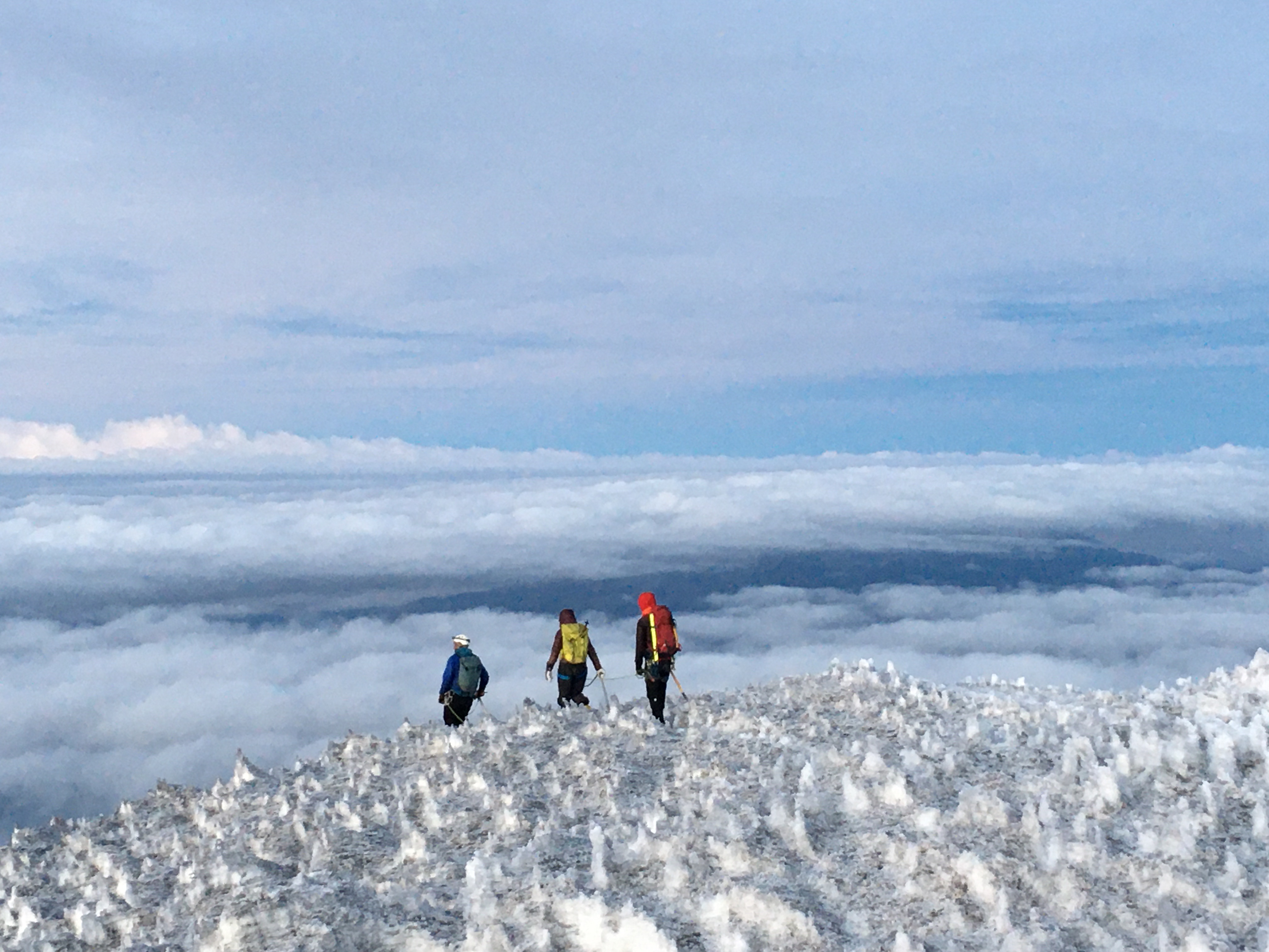
Group heading down from summit. The formation of snow you see is called penitentes. 
The real views of what we walked by, many had huge icicles dangling down
Lastly, Equipment, luckily most of which you can rent or is likely included in the cost of your guided tour. You can also bring your own technical gear. I basically rented most technical equipment (cost included through my guide) but you do need to bring your own base layers, and water proof layers. You may also want to bring extra clothes to change into afterwards to be dry (socks too).
- Base layers (primera capa) – wool long sleeve top (buzo manga larga) and bottom (pantalón)
- Waterproof (impermeable) jacket and pants (Goretex…)
- Thin warm layer jacket – either fleece or warm non-down jacket (softshell)
- Down jacket (chompa de pluma) – Use when it gets cold higher up on mountain.
- Gloves (guantes) for snow and warmth and thin gloves as a base layer
- Extra gloves in case they get too wet
- 2 pairs of wool socks (medias) Recommended: at least one long pair because boots are tall.
- Neck warmers (buffs)
- Wool hat (with some fleece would be great) – Not too thick so you can wear the helmet easily.
- Headlamp (linterna de cabeza) Bring extra batteries (pilas) or charger for it just in case.
- Sunglasses (gafas del sol) and sunscreen (protector solar) for when sun comes out (IMPORTANT)
- Backpack (mochila) – 45 liters (fit all gear, food and sleeping bag for walk to refugio)
- Plastic garbage bag (funda plástica grande de basura) Used to keep goods in backpack dry, basically a liner for backpack.
- Sleeping bag (Saco de dormir) Highly recommend a liner if you have it, otherwise there are blankets at the refugio.
- Helmet (casco)
- Harness (arnés)
- Piolet (Ice axe)
- Crampons
- Mountaineering boots (Botas de alta montaña) – You can not use regular hiking boots because they are not stiff enough to keep crampons on.
- Gaiters (Polainas)
- Water, 1.5 to 2 liters in bottles (not Camelbak because the hose can freeze). Bottles won´t freeze inside the backpack
- Camera
Guides must be ASEGUIM certified to climb Cotopaxi and most go through school to become a guide. I believe there are 180 certified guides in Ecuador, of which only 2 are female. All guides will have their credentials on hand. There are pirate guides that you do need to watch out for but they are not that common. There are many outfitters to choose from and I hear that the cheaper tours are found out of Baños, followed by Latacunga so you might go there and find a group. Cost to climb Cotopaxo is $270 and up. Some include everything (permit, lodging, guide, snacks, transport, equipment) others just some stuff. If you decide to use a freelance guide know they usually work with several tour agencies and though them they get the permits. They are legit but make sure you choose one you got as a reference to ensure they are also certified. Guide costs are $100 to $350 a day. Each guide will manage his services differently and know if you go freelance that $150 to $200 a day is an acceptable rate just for their guiding services.
Feel free to contact my references to get rates, date availability, etc. Most likely speak English or another foreign language since many work with foreign clients and some even guide around the world. Best is to contact them via Whatsapp…Ramiro Garrido +593 99 837 9479; Gustavo Cevallos +593 99 802 4469; Patricio Guaras +593 98 245 9688; Diego Castillo +593 99 850 7987; Mauricio Beltran +593 98 401 0531. If looking at agencies, try Our Trip Ecuador, Condor Trek, Kuntur Adventures, RMI Expeditions and Greenstep. Most of these agencies also offer training hikes every weekend for locals at lower costs which you might be able to join. This helps keeps costs lower plus it is more fun in groups and you can meet some cool Ecuadorians this way. Check their websites or social media accounts for updated information on monthly outings then write their whatsapp (no guarantees they speak English…although you never know until you try). Also if you want to sleep at high altitude for a night most do so at Illinizas at the hut at 4700m but you can also do the hut outside of Quito at 4500m below Guagua Pichincha. Both should be reserved in advance especially at Illinizas. For Guagua try writing in Spanish to Hugo (Hola Hugo, Está bien quedár en el refugio de Guagua el ____enter dates d/m/yr___ para __# of people__? Me cuentas, Sí o No por favor. Gracias. __Your name__) via whatsapp +593 98 409 0956.
Mountaineering, in case you don´t already know, is a dangerous sport but there are lots of things you can learn and do to help reduce the risk of accidents. Most of the time things turn out fine and I won´t go into details about what could happen but I highly recommend getting travel insurance for these types of activities. I get travel insurance depending on where I go and what I plan to do. In this case, I got it for this climb because I felt it was smart to have (por si las moscas)… I think this is the first activity I have done where I felt high risk (trust me I have done plenty of other high risk activities but this felt more serious). There is little phone signal in Cotopaxi National Park so contact loved ones before just in case anything happens (well there is a GPS SAT phone but still). As you get closer to the volcano…the dangers become more obvious….like when passing the flow area of the last eruption of Cotopaxi in 2015! Yes, Cotopaxi is an active volcano, the eruption in 2015 did have people on the mountain attempting summit but all got down safely and the mountain closed for 2 years following that event since the eruption in 2015 was totally unexpected. Something to be aware of but don´t let this stop you from living life either…get insurance ya know….just in case…Maybe also tell the loved ones where you are without scaring them and ya know say ¨I love you¨ too before doing these higher risk activities…just saying from experience of having forgot to do just that. Ooopsie.
Cotopaxi was quite the challenge and I’m happy to have made the summit on such a clear day. Though I don’t think I’ll do it again. Not sure how guides do this daily as it seems so brutal but I guess when you are as prepared as them it makes it easier to enjoy being this close to the moon before sunrise so often. I do have other ambitions for climbing other mountains so I guess I will focus on improving some technique before the next summit.

High Altitude Adaptation Details

2 thoughts on “Climb Cotopaxi Summit in Ecuador”